Useful Contacts
Medical / Other Emergencies:
021 480 7700
Pinelands Police:
021 506 2022
Local SAPS Patrol Vehicle:
082 411 2484
Ward Councilor Bryan Watkyns
083 444 4807 / Website
City of Cape Town
http://www.capetown.gov.za
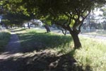
Running the canal
Each day, dozens of Pinelands residents - and visitors from
neighbouring areas - lace up their shoes and head out for a run through
one of the most beautiful suburbs in the country. Pinelands was
established in 1919 as the first "Garden City" in South Africa (and second in the world) and continues to attract both
young and old to its tranquil surrounds.
Pinelands is split roughly through its centre by the Elsieskraal
River which was canalised during the 1960s. Whether by design or simply
a fortuitous stroke of luck, the length of the
canal between the furtherest bridges is 2.5km - or 5km as a
circuit.
A number of years ago, distance markers were placed along the canal
and various different routes identified to cater for all exercise
requirements. Over time, these have been damaged, or simply
disappeared. In 2009, the markers were re-established with an
additional two routes included for those who wanted to run up to 10km.
The routes
The following measured routes have been included:
- 500m, 800m, 2km, 3km, 5km, 7km, and 10km
These routes were measured using a Garmin GPSmap 60CS. The device
indicated an error of about 5m, so the positioning of the markers
should be fairly accurate. From the GPS, data were extracted that allows
the routes to be overlayed on Google Earth - as well as uploaded to a
GPS unit should you so desire.
- Download: Google Earth data, GPS
Data
Note: Should you wish to convert the GPS data (xxx file) to your
particular unit, the site http://www.gpsies.com is particularly useful.
Note: On the 10km route, the
distance from the 3km to 4km marker is about 30m short. On the 7km
route, the distance from the 5km to 6km marker in about 60m short. Thus
the 10km run is about 100m short in total.
Click here to download a pdf of an aerial photo
with the routes indicated thereon. The red route is the 5km loop. If
you add the yellow route to the red, you get 7km and if you then add
the green route you get 10km. The yellow section is thus 2km and the
green is 3km.
- Click here to download Google Earth
Using the routes
 The
routes all begin at the bridge at the intersection of Howard Drive and
the Elsieskraal
River. The routes are colour coded and have marker-boards
indicating direction.
The
routes all begin at the bridge at the intersection of Howard Drive and
the Elsieskraal
River. The routes are colour coded and have marker-boards
indicating direction.
